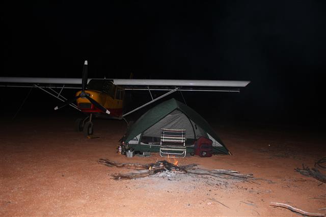
This is the story of a long adventure flight that I did in 2011.
This is the route that was flown.
Direct across the country at the widest point.
Around the Kimberly region.
Around the Pilbara region.
Then back home across the center.
144 hrs flying time.
Haven't added up the distance but at 80 kts that's about 11,500 nm, 21,000km.
Around the Kimberly region.
Around the Pilbara region.
Then back home across the center.
144 hrs flying time.
Haven't added up the distance but at 80 kts that's about 11,500 nm, 21,000km.
This is to show that Australia is almost exactly the same size as the lower 48 USA.
This trip will cross the Gibson, Great Sandy, and Simpson deserts.
Ready to load up, only personal effects to come.
All lightweight gear.
Even with full fuel comes under the 544kg allowed for this category.
Headed out over the Darling Downs cropping land.
Cubbie Station cotton harvest, the largest irrigation farm in the southern hemisphere.
96,000ha, 240,000acres
Nowadays the cotton is stored in very large round bails instead of modules.
The long red airstrip at Eulo is a welcome stop.
A good place to camp and just a short walk to the pub!
On the ground at Eulo.
This would be the only place that I know of where two 'rivers' to join to form a 'creek'....
The Thompson and Barcoo become Cooper Creek.
But Cooper Creek spreads into many channels, sometimes 70km wide.
The rivers are ephemeral, and only flow periodically, but then they spread out
and form this vast natural irrigation area.
Terrific cattle feeding country, wild cattle, no antibiotics or pesticides,
genuine 'organic' beef.
Cooper Creek working it's way through the 'Channel Country'.
More photos of the Channel Country in flood at http://www.stolspeed.com/id/99


Mungerannie Roadhouse along the Birdsville Track
I landed on that driveway to get fuel here.
These old trucks were used by the mailman Tom Kruse on the Birdsville Track
from 1936 to 1957.
In those days 'The Track' was unimproved and a real ordeal.
New facilities in the background.
This is a natural hot pool at the roadhouse.
The water is just the correct depth that you can sit on one of those chairs and soak.
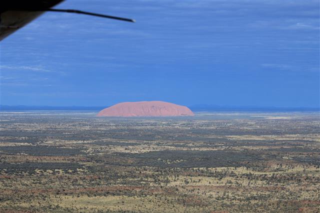
Uluru (Ayers Rock) in the morning light.
Kata Tjuta rock formation, from altitude, headed west.
Following the 'Gunbarrel Highway' headed west.
Why would they put such a bend here, with no obvious reason??
Camped at the first airstrip in Western Australia,
after a long flight over remote 'tiger country'.
The first of many gold mines in Western Australia.
A long Western Australia highway.
In this very flat country roads don't need curves....
In this very flat country roads don't need curves....

A very welcome airstrip in this remote country.
First sight of the Pacific Ocean, at last!
The west coast of Australia
No development here, very different from the Gold Coast on the other side.....
Fringing reef.
That storm hung on the NW coast for two weeks so I had to go inland around it.
This is how it looked on the GPS.....
It's the largest gold mine in Australia.
.........................................................................................................
.........................................................................................................
Smoke from burning-off fires.
These fires are deliberately lit to burn off last year's dry growth.
If done properly like this one, they burn slowly and prevent a buildup
of fuel that could result in a destructive wild fire.
Missionaries at Derby.....
The town of Derby, surrounded by mud flats.
The tide range here is 11.8m (39ft) so that means lots of mud......
Dock for loading live cattle for shipment to Asia.
Those extreme tides rush in and out of these estuaries.
Some treacherous currents through there.
Great shelter for cruising yachts.
Iron mining on Cockatoo Island.
At Fitzroy Crossing two of the richest men in Australia arrived from Perth,
each in his own identical luxury jet.....
They were negotiating with the Aboriginals
for permission to mine or drill for gas on their land.

I'm sure that Aboriginals would have camped by that beautiful pool.
A termite mound 'suburb'.
The Wolfe Creek meteorite crater.
Sign on the gate at Halls Creek airport.
The scene on the way into town.....
The dam that holds in Lake Argyle.
The dam was constructed in order to supply the Ord River irrigation project.
The dam was constructed in order to supply the Ord River irrigation project.
Lake Argyle.
Sandalwood plantations expanding in the irrigation district.
The Ord River Scheme would seem to have great potential,
with plenty of water and viable land and tropical climate,
with plenty of water and viable land and tropical climate,
but it hasn't been very successful at all.
I worked up there in 1969 when it was just starting out,
when cotton was the big hope.
when cotton was the big hope.
By 1974 the cotton industry was dead - too many bugs.....
Rice was tried but the wild geese ate the seedlings and fungal disease finished it.
This is a hot tropical climate and bugs and fungi love it!
Sugar was tried, but falling prices and increasing salinity finished that in 2007.
Mangoes and watermelons grow well but cost so much to get to markets.....
Now sandalwood is taking over most of the land.
It's a natural insect repellent so makes sense in this climate.....
But seems to me to be a waste of a grand irrigation project just to grow trees
to make into smelly incense sticks, regardless of the potential profits....
Another sobering lesson in the dreams for tropical agriculture.........
Now Chinese companies are trialing various crops,
we'll see what they can do......
we'll see what they can do......
Nearby is the Argyle Diamond Mine.
They've cut away that whole mountain.
Very productive, but mostly low quality brown diamonds.
But some very rare pink diamonds that bring very high prices.
The Chamberlain River.
Scarred by raging floods last season.
The debris lodged way up those trees shows the depth of the floodwater.
Patterns on the flood plain near Wyndham.
King George River gorge.
Open to the ocean and good shelter for boats.
King George Falls
Boats and yachts can access right up to the falls.
Scenery along that remote NW coast.
How's that for a perfect beach.
Only problem up here might be a crocodile that considers it his/her beach.
Prince Reagent River.
This river is along a straight line natural fault line in the rock.
Interesting patterns in the flood plain near Derby.
Real crocodile country.....
Those dark areas are probably iron ore deposits.
The geologic uplift was been so slow that the river could cut through across the ridges.
An abandoned airstrip in the middle of the Kimberleys.
Just what I seek to find!
Burrs stuck to the tires.
Camped way out in this wonderful wilderness
There was even this beautiful clear stream nearby.
Very rare in Australia.
Termite mounds.
These are only about man high, but can be much larger out here.
Landed off-field and camped near some interesting boab trees.
These strange trees seem to me to have identities.
A fair young couple.
A beautiful young mother and daughter.
Father and son.
An elderly fella.
.......................................................................................................
Across the Great Sandy Desert
Nowadays there are many 4wd expeditions travelling the old stock route.
But recently there had been unusual heavy rain,
and this flooded section had closed the track for now.
I had hoped there would 4wds along the way in case I had problems,
but now I'd be on my own with no back-up......
Not a real good idea to proceed, but I did anyhow.....
Just desert, on both sides.....
A bit green from the rain, but no standing water anywhere.....
No open clay pans to land on, just sand and brush.....
No open clay pans to land on, just sand and brush.....
It's hard to see from the air, but this is a big dune.
The track enters from the upper left,
then comes back down through the center, then turns around.
That's to give the vehicle a run at the dune to get over it.....
Camped under a full moon at Well 33.
Sunrise at Well 33
There's lots of growth after all that rain,
so there's going to be a fire hazard when it all dries out.
This is the sort of mosaic burning pattern that Aboriginals perfected long ago.
The slow burn rate and patchiness allows small animals to escape,
then new grass sprouts up in the burnt area and attracts the animals back there,
so hunters know where to find them.
It's a successful method of 'firestick farming'
Just the ideal sort of patch burn.
Probably lit at night, with falling dew extinguishing the fire.
Kunawarritji Aboriginal community, near Well 33
a long way from anywhere else....
This is their only road to the nearest settlement.
There about a million feral camels in Australia....
.....................................................................................................
The Pilbara Region
Iron ore deposits in the Pilbara Region
The pattern of holes drilled to outline the ore deposit.
Drilling all those holes is hot, dusty, noisy hard work.
Capricorn Roadhouse, a real truck stop!
These trucks have just arrived from Perth, with equipment for the mines.
This is one of the trucks that haul the iron ore to the coast.
That's an 86 wheeler!
All with big 'bull bars' to deal with stray cattle and kangaroos that get in the way.
Lots of road kill on those roads.....
Big toys for big boys....

The Avis rental fleet at Newman airport,
all with bull bars and safety flags required on the mine sites..
Mt Whaleback mine at Newman.
The largest single-pit open-pit iron ore mine in the world.

Loading trains to transport the ore to Port Hedland.
Long, long trains headed for the coast.
Loaded trains going down,
empty trains coming up.
Port Hedland, ore loading on the left, salt production on the right.
Loading iron ore into the ships.
Ships waiting to load.
800 ships are loaded each year.
Iron mines everywhere.
And 'man camps' to staff them.
And remote runways long enough to handle big passenger jets.
Most staff are FIFO (Fly In Fly Out) from all parts of the country.
An old abandoned mine.....

Gorges in Karijini National Park

The abandoned blue asbestos mines at Wittenoom.
Many painful deaths worldwide due to this asbestos....

The ghost town of Wittenoom, population 3 now....
A highway through the Pilbara
...........................................................................................
An island adventure.
I'd heard about an uninhabited island off the coast, with an abandoned airstrip.
So I just had to go.....
Rosemary Island, off Karatha.
There's the trace of the old strip, looks very overgrown......
I could see from the air that the grass was deep,
but didn't realize that each clump was a mound of sand, washed in there by floods.
Each mound was as big as a basketball, so the landing was VERY ROUGH....
Luckily didn't break anything, but can't take off again.....
Looked like I was going to have to hire a barge to bring a bobcat, a very costly mistake.....
I found that, with lots of wrestling, I could tear the clumps apart one handful at a time.
But it sure was hard on my hands....
Finally got 80metres cleared, took all day....
So, work done, decided to stay another day and explore the island.
Found this old Aboriginal midden where they had feasted on shellfish.
Lots of delicious small oysters on these rocks.
Next morning blasted off that short strip,
with a 20kt Xwind not giving any help.
Rolled right to the end and then a sharp turn into wind to lift off,
nothing to spare, whew.....
...............................................................................................
On the way home again.
Tjukayirla Roadhouse, along the Great Central Road.
Most of the road is corrugated gravel, but this short section is paved
and declared an aircraft landing strip
for the Flying Doctor Service.
But when I landed there a few years later
I got reported to CASA and received a slap on the wrist.....
Not allowed to land on a road without police on hand to stop traffic.
Speaking of the Flying Doctor,
here he is at the Giles Weather Station/Ngaanyatjarra Aboriginal community strip
picking up an elderly Aboriginal woman to go to hospital.
Interesting patterns in the Petermann Ranges.
Crossing the Simpson Desert.

An abandoned airstrip from the oil exploration in the 60's.
One of my favorite remote camping sites.
You can just see the old seismic line crossing the dunes.
Now called 'The French Line', and a popular challenge for 4wds.
Parked at Birdsville.
Drilling for coal seam gas, now stopped due to environmental damage to water supplies.
Back over the rich farmland of the Darling Downs.
Almost home....
One last obstacle, a pretty rainbow but a storm to be dodged.


Memories of many happy camps along the way.
...................................................................
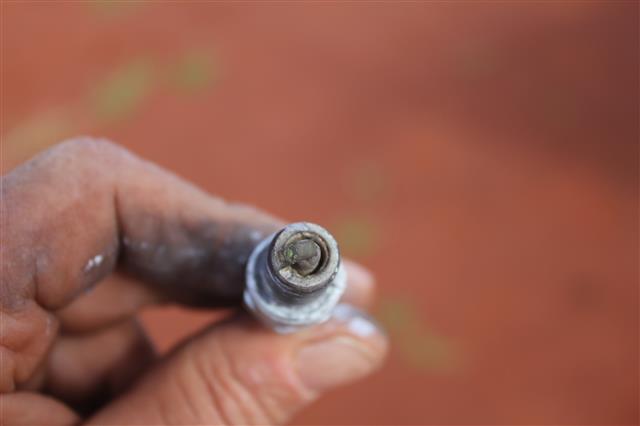
The consequences of running on Avgas....
This was after 70hrs running time, not all but much of it on Avgas.

Failed a mag check and the first plug pulled looked like this....
The points were completely shorted by lead deposit.......

All plugs looked like this......
......................................................................

Cheers,
JG


No comments:
Post a Comment